香港得名考:你知道「香港」這個名字是怎麼來的嗎?
Share
關於「香港」之名的起源,民間歷來流傳著與香料生產有關的說法。沙田城門河谷西臨針山的香粉寮確實曾以種植香木、生產香料聞名,但這只能證明香港地區很早就有製香產業,並非「香港」名稱的真正來源。
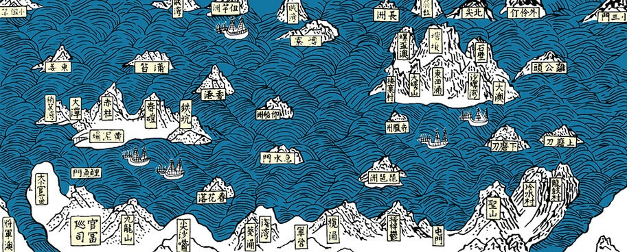
根據香港歷史博物館前總館長丁新豹博士在《香港歷史散步》中的考證,「香港」地名最早見於明萬曆二十三年(1595年)郭棐所著《粵大記・廣東沿海圖》。這份珍貴的地圖現存於大英圖書館,在圖中今日黃竹坑與鴨脷洲一帶已明確標有「香港」字樣(註1)。這比普遍流傳的「莞香轉運說」還要早近百年,顯示香港地名源遠流長。
康熙《新安縣志》卷三〈地理志〉記載:「香港村原為東莞香木集散地」,證明明代嘉靖年間已在石排灣附近設立「香港村」,專門負責東莞香木的轉運貿易(註2)。清初實施海禁政策後,這個村落一度廢棄,直到乾隆二十四年(1759年),才由周啟文在黃竹坑舊圍重建村落,稱為「香港圍」,也別稱「小香港」。
值得一提的是,從南朗山流入香港仔海峽的溪水(今黃竹坑明渠)清澈甘甜,過往船隻常在此取水飲用,這讓香港又得「香江」美名。1841年英軍在赤柱登陸後,根據英軍測量官哥頓(A. Gordon)的《香港島勘測報告》,帶路村民陳群用客家話告知此地名為「Hiong Gong」(香江),英人便以「Hong Kong」記錄,並以此稱呼整個島嶼(註3)。
1860年,由於舊圍土地不敷使用,周氏家族向東擴展建立新圍村。1866年繪製的《新安縣全圖》中,黃竹坑一帶正式標註為「香港圍」。在日本佔領期間,新圍甚至曾改名為「元香港」,寓意「香港的起源」,可見這個地名在歷史中的重要地位。
如今,舊圍因香港仔隧道工程而被拆除,但新圍仍保留著一座10號古民居,這座二級歷史建築採用傳統的一進一院式格局,默默見證著從明代至今的地名演變歷程。香港歷史博物館珍藏的《粵大記》地圖複刻本,以及大英圖書館收藏的1841年英軍勘測原始文件,都為這段歷史提供了珍貴的實物證據。
考證來源:
註1:丁新豹,《香港歷史散步》(2007年),頁38-45
註2:康熙《新安縣志》卷三〈地理志〉
註3:A. Gordon, "Survey of Hong Kong Island" (1841), The National Archives, UK
延伸閱讀:
· 科大衛,《香港簡史》(2016年),香港大學出版社
· 《香港地區史研究:新界與離島》(2012年),香港地方志辦公室
圖片:
明萬曆23年(1595))的《粵大記.廣東沿海圖》
The Origin of the Name "Hong Kong": How Did Hong Kong Get Its Name?
The origin of the name "Hong Kong" has long been associated with the production of incense in popular folklore. While the incense village of Heung Fan Liu in Sha Tin, nestled in the Shing Mun River Valley west of Needle Hill, was indeed renowned for cultivating fragrant trees and producing incense, this only proves that the incense industry existed in the Hong Kong region very early on—it is not the true source of the name "Hong Kong."
According to research by Dr. Joseph Ting Sun Pao, former Chief Curator of the Hong Kong Museum of History, in his book 《香港歷史散步》,the name "Hong Kong" first appeared in the Yue Da Ji・Guangdong Coastal Map compiled by Guo Fei in the 23rd year of the Ming Wanli era (1595). This precious map, now housed in the British Library, clearly marks the area around present-day Wong Chuk Hang and Ap Lei Chau with the name "Hong Kong" (Note 1). This predates the commonly circulated "incense trade theory" by nearly a century, indicating that the name Hong Kong has a long and rich history.
The Kangxi edition of the Xin'an County Annals (Volume 3, Geographical Records) states: "The original Hong Kong Village was a distribution center for incense wood from Dongguan," confirming that during the Ming Jiajing era, a "Hong Kong Village" was established near Shek Pai Wan specifically for the trade and transportation of Dongguan incense wood (Note 2). After the sea ban policy was implemented in the early Qing dynasty, the village was abandoned until the 24th year of the Qianlong era (1759), when Zhou Qiwen rebuilt the village at Wong Chuk Hang Old Village, naming it "Hong Kong Wai" or alternatively "Little Hong Kong."
It is worth mentioning that the stream flowing from Nam Long Shan into Aberdeen Harbour (now the Wong Chuk Hang Nullah) was known for its clear and sweet water, often used by passing ships for drinking. This earned Hong Kong the beautiful name "Fragrant Harbour." In 1841, after British forces landed in Stanley, according to the Survey of Hong Kong Island by British surveyor A. Gordon, local villager Chan Kwan informed them in Hakka that the place was called "Hiong Gong" (Fragrant Harbour), which the British recorded as "Hong Kong" and subsequently used to refer to the entire island (Note 3).
In 1860, due to insufficient land in the Old Village, the Zhou family expanded eastward to establish a New Village. The 1866 Complete Map of Xin'an County formally labeled the Wong Chuk Hang area as "Hong Kong Wai." During the Japanese occupation, the New Village was even renamed "Yuan Hong Kong" (Original Hong Kong), symbolizing the origin of Hong Kong, highlighting the historical significance of this name.
Today, the Old Village has been dismantled due to the Aberdeen Tunnel project, but the New Village still preserves a No. 10 ancient dwelling, a Grade II historic building designed in the traditional "one-hall-one-courtyard" style. It quietly bears witness to the evolution of the name from the Ming dynasty to the present. A replica of the Yue Da Ji map housed in the Hong Kong Museum of History, along with the original 1841 British survey documents in the British Library, provides valuable physical evidence of this history.
Sources:
Note 1: Dr. Joseph Ting Sun Pao 《香港歷史漫步》 (2007), pp. 38-45
Note 2: Xin'an County Annals, Kangxi Edition, Volume 3, Geographical Records
Note 3: A. Gordon, "Survey of Hong Kong Island" (1841), The National Archives, UK
Further Reading:
· David Faure, A Brief History of Hong Kong (2016), Hong Kong University Press
· Research on Hong Kong Regional History: New Territories and Outlying Islands (2012), Hong Kong Local Records Office
Image:
The Yue Da Ji・Guangdong Coastal Map from the 23rd year of the Ming Wanli era (1595).